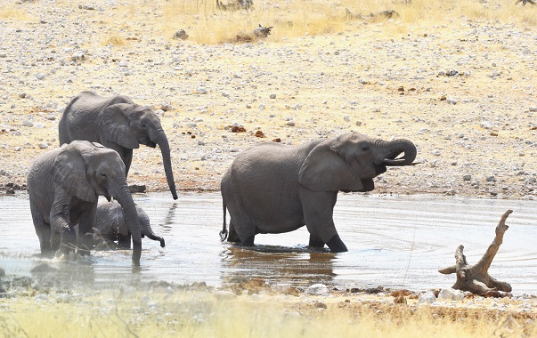
Little Bighorn Battlefield National Monument

Walk on the Custer Battlefield

I am sure everyone knows what happened at the Battle of the Little Bighorn. However, walking on the battlefield changes the impression in your mind from history to reality.

The battle occurred on the 25th and 26th of June, 1876. It was a battle between the Lakota Sioux, Northern Cheyenne, and Arapaho tribes and the United States Army, specifically the 7th Cavalry. I will not go into the details of the battle or General Custer’s decisions. This post is about the experience of walking on the battlefield today. However, I will mention some little-known facts that are usually not included in the history of the battle.

Little Know Facts of the Battle

  • What was General Custer’s real military rank?
  • Where is General Custer’s grave?
  • Whose land was it?
  • Where are the Indians buried?
  • What happened to the dead horses?
  • Who is General Reno?

The Battlefield Today.

As you enter the battlefield, it may be crowded around the entrance. the cemetery and the museum. The parking lot might be full. If you go early in the morning, few people will be there.

What was once a bloody battlefield is today a very tranquil and peaceful National Monument park. It has an area of 765 acres (310 ha). The park was created in 1879.

Once you leave the crowded entrance area, you will find a hilly grass-covered landscape with some walking trails. Scattered throughout the park are markers where individual soldiers died. You might even see a group of Wild Turkeys that live there. (click photos to enlarge).

Some of the markers are inscribed as “unknown US Soldier”. It took some time before the military could regain control of the battlefield. By then, some of the bodies were unidentifiable. Much of their clothing and belongings were taken away by the Indians.

Custer’s Last Stand

The battle raged over a large area for two days, but the most famous was “Custer’s Last Stand”. This is where General Custer was killed. There is a memorial to the 7th Calvary and a fenced area with markers showing where Custer and the men of his headquarters died. It is now known as “Last Stand Hill”.

General Custer’s Grave

The photo above shows the markers where Custer and the men with him were killed. The one with the black crest on it is Custer’s. Note that his rank was Lt Colonel, not General. He was temporarily assigned the rank of Major General for the campaign.

Indian Markers

Click on the first photo to enlarge it, then scroll through them.

There are some markers on the battlefield where some of the Indians died. However, no Indians are buried at the Monument. After the battle, the Indians took all the bodies of their fallen comrades away for burial down by the Little Bighorn River, which can be seen in the distance.

The Indian Memorial

There are several memorials around the Monument. There is a very nice one for the Native Americans who died in the battle.

The Horse Memorial

There is even a cemetery and memorial for the many horses that died in the battle.

The Cemetery

Be sure to spend a bit of time at the cemetery. Walking among the graves and reading the tombstones is very interesting.

Where is Custer and Reno?

General Custer’s grave is not to be found at the Monument. His today was taken away and buried at West Point in New York State,

Everyone knows of General Armstrong Custer, but most people have not heard of General Reno. Reno was Custer’s second in command of the 7th Calvary. He survived the battle.

Ironically, General Custer, who died at the Little Bighorn, is buried in New York State. General Reno retired to New York after his military career. He requested that when he died, he be buried at the cemetery at the Little Bighorn Battlefield to be with his men. He died in 1834.

Whose Land was it?

The Common knowledge is that the land belonged to the Indians, and the US Army was taking it away from them. This is not entirely true. The land belonged to the Crow Indians and still does today. The Sioux, Cheyenne and Arapaho were trying to take the land away from the Crow. The Crow did not participate in the battle. They were hoping that the Calvary would win. In fact, several Crow Indians joined the US Army and fought with them against the other tribes who were trying to take their land. Several of them are buried in the cemetery on the battlefield. I had a long conversation with one of the Crow Indians who works at the museum, who confirmed this story.

The Museum

Be sure not to miss the little museum. It has some fascinating artefacts.

Subscribe

If you enjoyed this post, please subscribe to my newsletter on the home page. You will be notified whenever there is a new post. Posts are not that frequent, so you will not be inundated with them, and you can unsubscribe at anytime.

The Devils Tower

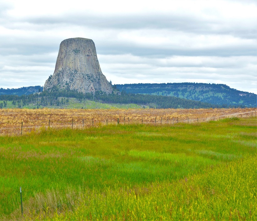
The Magnificent Monadnock

Keep reading to learn what a monadnock is.

Devils Tower is located in the northeast corner of Wyoming in the USA. The tower was formed about 40 million years ago when lava from the earth’s centre spread horizontally below and erupted through a weak spot in the earth’s crust. This would form what would appear to be a small mountain. Over millions of years, erosion took away the soil, leaving only the tower of magna, which has cooled and turned to rock.

The facts

  • The tower is 867 feet (264 metres) tall
  • The top is flat with an area of 1.5 acres (0.6 hectare)
  • The proper name of the monument is Devils Tower, not Devil’s Tower according to the rules of grammar. When the monument park was named, the apostrophe was accidentally omitted, and the word without the apostrophe has been the official name ever since.

A National Monument

President Theodore Roosevelt declared the area around Devils Tower a National Monument in 1906. A National Monument is similar to a National Park but with a slightly lower status. They receive less funding than a National Park. The president of the USA can create a National Monument, but a National Park can only be created by Congress.

Devils Tower National Monument has an area of 1,347 acres (545 ha). There is an admission fee of $25 per vehicle. (Actually, it is more like an exit fee as you pay on the way out, not when you enter. At least when I was there. Perhaps that is only at the busiest times to prevent a lineup on the highway, So the lineup is inside the park instead.)

There are no restaurants in the park. However, there is one just outside the gate. So eat before you go in or bring a picnic lunch.

What’s on the top?

The area on the top of Devils Tower is kind of barren, but there is grass, cactus, and flowers. There are birds, chipmunks, mice, woodrats and other wildlife including snakes. I took it for granted that birds would be there, but I was amazed to learn that snakes were also there. Many people climb the tower every year.

What to do there

Photography

Here are a few photography tips for the Devils Tower.

  • Get some photos from a distance, not just ones close to the tower (Like the one above).
  • Place the tower to the left or right of the photo. It looks better than in the centre.
  • Photograph the tower at sunset when it appears to be a gold colour. During the day it is grey.

Hiking

Besides taking photos, the most popular activity at Devils Tower is the hike around the tower’s base. This trail is 1.3 miles long and takes about one hour to complete on average.

Watch for snakes. Bull Snakes are common at the monument. They look like rattlesnakes but are not venomous, although they could probably give you a nasty bite if you molest them. Leave them alone, and they will not bother you.

There are other trails in the monument, further away from the tower, if you want to take a longer hike. The trail around the tower is often crowded, whereas only a few people hike the other trails.

Climb the Tower

It is permissible to climb the tower if you are capable. You must register at the park office before climbing.

Night Sky Viewing

Devils Tower is far from any town, so there are few electric lights. It is a great place to view the stars. There are ranger-led night sky walks where the park ranger will explain the constellations to you, or you can marvel at the beauty on your own without going for a walk.

Camping

There is a campground at the monument, a KOA campground just outside the gate, and another short drive down the highway to the south called Devils Tower View. The campground inside the monument has no facilities, and the KOA is expensive. We stayed at Tower View. It is an excellent place with plenty of space for large RVs and a good restaurant and gift shop.

A Sacred Place

Devils Tower is a sacred place for the local Native Americans. You might see bundles of multi-coloured cloth tied in the trees. These are prayer cloths put there by the Indigenous people during their prayer ceremonies each June. They ask the people not to climb the tower during June, but this is optional.

What is a Monadnock

A Monadnock is an isolated hill of bedrock standing conspicuously above the general level of the surrounding area.

Cholula

PYRAMIDS, CHURCHES, VOLCANOES – CHOLULA

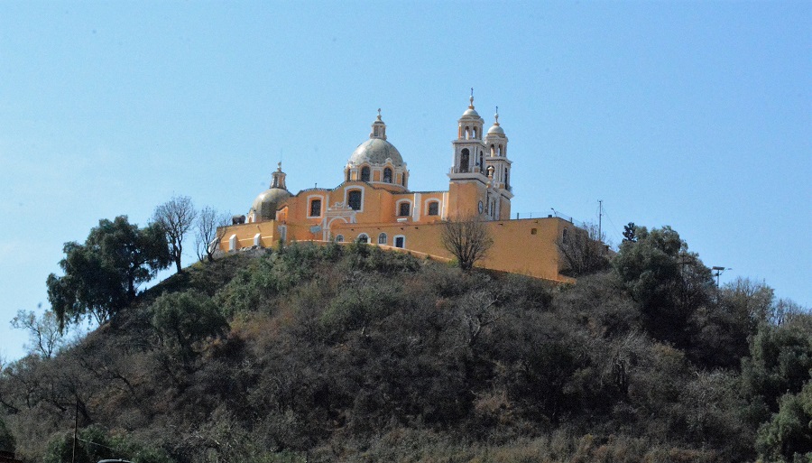
Have you ever seen a Christian church built atop an ancient pyramid with an active volcano in the background? You can in Cholula, Mexico. Updated Mar 2023.

Iglesia de Nuestra Señora de los Remedios

Cholula

Iglesia de Nuestra Senora de los Remedios (in English –  the Church of Our Lady of Remedies) is located on top of what appears to be a large hill in the city of Cholula, Mexico.

The Spanish Conquistadors conducted a battle of occupation with the local Aztec natives in the 1500s. At Cholula, the natives defeated the Spanish at the battle of Sad Night on 30 June 1520. The Spanish retreated, recovered and attacked the Aztecs again, this time victorious, in the Battle of Otumba on 7 July 1520.

Cholula

After conquering Mexico, the Spanish began building Catholic churches in every town. The construction of the church in Cholula started in 1574.

The Great Pyramid of Cholula

The Spanish thought that they were building their church on the top of a large hill.   They did not realize it was not a hill but an ancient pyramid. Not just any pyramid, but the largest pyramid in the world. How was it possible that the Spanish did not discover the pyramid, which remains primarily unknown today?

The Aztec name for the pyramid was Tlachihualtepetl.   It is only 66 metres (217 feet) tall, which is slightly less than half the height of the pyramids in Egypt. However, the pyramid’s base is an incredible 450 metres by 450 metres (1,480 feet), making the total area of the pyramid massive in size and covering an area of 54 acres. At 4.45 million cubic metres, it is almost double the volume of the largest pyramid in Egypt.   Although not the tallest, it is the largest pyramid in the world in total size.

Construction and Decline

Construction of the pyramid started in the 3rd century. By the 9th century, it was complete, with seven superimposed levels. The pyramids in Egypt were built as tombs for their kings, while the ones in Central America were temples. The Great Pyramid of Cholula was dedicated to the god Quetzalcoatl, a feathered serpent, who was the god of wind and learning. During this period, Cholula was the second-largest city in Mexico after Mexico City, with a population of about 100,000.

In the 8th century, like in other Central American cities, the population began to decline. The cities of this era suffered from overpopulation, wars with other cities, insufficient food and drought. Like several other Aztec and Mayan cities, they were mostly abandoned long before the Spanish arrived in the 1500s.    However, thousands of Aztec people still lived in the area when the Conquistadors arrived and put up a fight against the occupation. By then, the pyramid was overgrown and unrecognizable and appeared to be just a large hill.

The Pyramid Today

Amazingly, the world’s largest pyramid was not discovered until the 20th century. Exploration began in 1931. However, today the pyramid remains mostly overgrown with centuries of dirt, grass, bushes and trees, just as the first Spanish saw it in 1520.

Cholula

The photo above shows a small portion of the pyramid after removing centuries of dirt and growth. Visitors can now imagine what the entire structure looks like. It must have been beautiful indeed. The pyramid has not been uncovered because of the religious significance of the church on top of it. If you go up the stairs, you arrive at a level area with no other place to go, as this is all of the pyramid that has been uncovered. Initially, you would have crossed this level and continued up another set of stairs to the second of seven levels.

The Tunnels

Cholula

The pyramid is full of tunnels. Over 25 years, excavation revealed eight km of tunnels. About 800 metres of these tunnels are now open to the public and are well worth exploring.

Popocatepetl

Popocatepetl

Popocatepetl is an active volcano in central Mexico, south of Mexico City.   It has a height of 5,426 m (17,802 ft). In Mexico, it is known as “El Popo”.

On the internet and in Cholula, you will see photos and postcards of the Church with Popocatepetl in the background.   Although you can see the volcano from the church, it is far away and not directly behind the church, as shown in the famous photo. This is a compound image made up of two different pictures.

There was a significant eruption in the first century, after which Popocatépetl became dormant and was declared inactive until 1947, when another massive eruption occurred. In 1991 the volcano’s activity increased, and since 1993 smoke can be seen emanating from the crater almost daily. The volcano has become increasingly active in recent years, with 14 major eruptions.

Eruptions since 1900

Minor eruptions: 1363, 1509, 1512, 1519–1528, 1530, 1539, 1540, 1548, 1562–1570, 1571, 1592, 1642, 1663, 1664, 1665, 1697, 1720, 1802, 1919, 1923, 1925, and 1933.

There was a major eruption in 1947.

21 December 1994.   An eruption of gas and ash carried 25 km, causing the evacuation of nearby towns.

December 2000,  The biggest eruption in 1,200 years.

25 Dec 2005. Smoke and ash rose 3 km into the air, and there was an eruption of lava.

25 Jan 2012. A large explosion of ash

15 April 2012. An explosion of ash and rocks over a period of 24 hours.

8 May 2013.   An eruption lasting 3.5 hours covered nearby villages and the City of Puebla with ash. Volcanic rock was flung up to 700 metres from the crater.

4 July 2013. An eruption of steam and ash lasted for 24 hours.

During Aug and Sep 2014, steam and gas rose to 3,000 metres above the crater.

28 March 2016. A column of ash rose 2,000 metres in the air. Since then, a 12 km security ring was established around the volcano in which people are not allowed to live but may visit.

3 April 2016. A minor eruption of ash, rock and lava.

17 Aug 2016.   Four minor eruptions over a 24-hour period.

10 Nov 2017. The most recent eruption.

I visit Popocatepetl – Mar 2018

In March 2018,  I observed the volcano from the top of the pyramid in Cholula. The volcano was also clearly visible from the City of Puebla, about 26 km away on the east side of the mountains.   Steam rose from the crater on most days that I saw the volcano.

Popocatepetl

Later in the month, I travelled around to the volcano’s east side via Mexico City.   From the town of Amecameca, you can drive up to Iztaccihuatl-Popocatepetl National Park for a close look.   Steam rises from the volcano on most days, but unfortunately, Popocatepetl was quiet on the day I was there.   I had hoped to get some photos with some activity as I was within five km of the volcano. However, a few days later, the volcano was active again.

Camping and washrooms are available in the park at the visitor’s centre.

Popocatepetl Eruptions

Popocatepetl erupts often. Not enough to destroy nearby towns, but can often be seen belching smoke.

Birds at Popocatepetl

Incidentally, Popocatepetl National Park is a good place to look for birds.   Steller’s Jay and Striped Sparrow are common.

The Next Eruption

Popopetcatepetl is due for a major eruption at any time.

Warning:  Stay on the road or within the boundaries of the park.   Do not go hiking in the forest outside of the park. Bandits are known to inhabit the area. It is safe within the National Park as it has a large police presence.

BANFF NATIONAL PARK IN WINTER

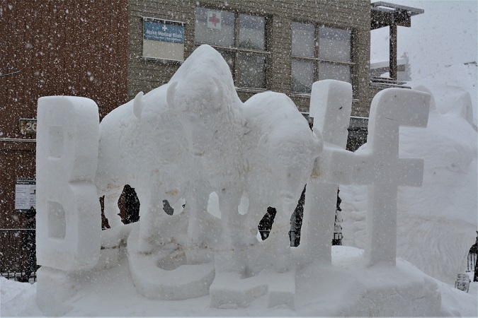
What to see and do in Canada’s premier winter wonderland. Updated Jun 2022

Snow Sculptures

Banff winter

Have you ever built a snowman?  Each year, in mid-January, people create spectacular, giant snow sculptures in the town of Banff.

Banff

You might encounter a Polar Bear but don’t worry; they will melt in the spring.

Banff

You will have to go to the Himalayas or Siberia to see a Snow Leopard, but in Banff, you might see a Snow Wolf.

Banff

How is this for a snowman?

Go up the Banff Springs Gondola to the top of Sulphur Mountain.

Banff

Take the Banff Gondola 2,281 metres (7,486 ft) to the top of Sulphur Moutain for spectacular views of the Canadian Rocky Mountains.   The modern four-level building at the top of the mountain has a restaurant, a gift shop, wildlife displays, toilets, and an observation platform on the roof.   There is also a boardwalk to a nearby peak.  Be aware that the weather at the top of the mountain may not be the same as in the valley below.  It could be foggy, which spoils the view, and it might be about ten degrees colder than at the bottom, so dress warmly.   Ask at the ticket office before purchasing your ticket.

Wildlife that you might encounter includes Rocky Mountain Sheep and Canada Jays.

Banff

Restaurant with a view

Hot Springs

Banff

The Banff Hot Springs is a great place to spend some time on a cold winter day.   It is cold getting in, but the water is hot, and you will feel fantastic and relaxed when you get out.   The hot springs is open all year but is best in winter.

After your swim, visit the Cave and Basin to see the original hot springs discovered in 1883.

Johnston Canyon Hike

Banff

The Johnston Canyon hike is the most popular trail in Banff National Park.  It is so popular that, in summer, the massive crowds often spoil the experience.   I have done this hike many times, but this was my first time in winter.  It is even more beautiful than summer, although it can still be crowded on weekends.

Banff

At the end of the hike, you will be rewarded by the sight of a frozen waterfall.  Something that most people will never see.   The first falls is a short 1.1 km (0.68 miles) walk.   You then have the option of turning back or going further.    The next waterfall is a little taller, and the third, the upper falls is the tallest.   From the first lower falls to the upper falls is an additional 1.6 km (one mile).  The trail to the first waterfalls is slightly uphill, but most people of average fitness can do it.  Going further to the Upper Falls is steeper and is for people with a better state of fitness.

There is waterfall climbing for people who want an adventurous winter sport other than skiing.  Sort of like mountain climbing, but these people climb up frozen waterfalls.

The Banff Springs Hotel

Banff
Banff

After a day of hiking and exploring, visit the majestic Banff Springs Hotel. Opened in 1888, this magnificent hotel is worth a visit, although expensive to stay overnight. You can enjoy an English tea time (which is a meal and not just tea) by the big windows at the back (seen in the photo above). Watch out for the ghost who died here on her wedding day in 1920.

Ice Castle at Lake Louise

Banff

Have you ever walked on water?   Frozen water, that is.  Take a walk on the icy surface of Lake Louise and get your photo taken at the ice castle.

Ice Sculptures

Banff

Check out the amazing ice sculptures at Lake Louise.  Unlike the snow sculptures, which get destroyed after the snow festival in January, the ice sculptures will be there until they melt in the spring.

Banff

Ice Skating and Cross-country skiing

Banff

Go skating or cross-country skiing on the frozen surface of Lake Louise.  Equipment is available for rent in the hotel if you do not have your own.

Horse-drawn Sleigh Rides

Banff

A horse-drawn sleigh ride along the shore of Lake Louise is fun on a snowy day.  You can purchase tickets at the hotel.  You probably will not need a reservation during the week but will need one on weekends and holidays.  The telephone number is 403-522-3511 Ext 1210.   The ticket office opens at noon on weekdays and earlier on weekends.

Riding through the forest on a two-horse open sleigh! The sleigh goes onto the lake at the midway point to turn around. So you can say you rode in a horse-drawn sleigh on a frozen lake.

BanffEat a Beaver Tail

After an exhilarating day of skating on the Ottawa canal or Lake Louise, it is time for a hot chocolate and a Beaver Tail.   You have to try this delicious and unique Canadian treat.   No, it is not a real Beaver’s tail.   It is a flat doughnut in the shape of a beaver tail.    You can get them will all kinds of toppings, but the best is still the original, which has only cinnamon and sugar on it (and it is also the cheapest one).   If you like doughnuts, you will love Beaver Tails.

Banff

Skiing and Snowboarding

The vast majority of people that you see in Banff during winter are there for skiing and snowboarding.  Some of Canada’s best ski slopes are nearby.  However, in this post, I wanted to tell you about the lesser-known winter activities.

See you there

I spend a lot of time in Banff.   It is one of my most favourite places in the whole world.  See you there!

DENALI NATIONAL PARK – PLAN YOUR VISIT

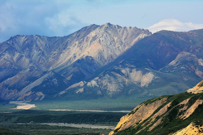
Updated 29 Jan 2023.

Denali National Park

Denali

Plan your visit to Denali – the vast Alaskan wilderness park.  Denali National Park was created in 1917, but there was no road access until 1957.  Previous to that date, visitors arrived by train.

The park consists of six million acres (24,000 km2).  There are plenty of places to go and things to see for both the adventurous and the not-so-adventurous.

Getting There

Denali National Park is located about 240 miles (386.24 km) north of Anchorage and 120 miles (193.1 km) south of Fairbanks.  It is 12 miles (19.31 km) south of Healy, which is the nearest year-round community.

Alaska’s state-owned railroad connects Anchorage to Fairbanks and stops at the entrance to Denali (for more information, visit Alaska Railroad).

Accommodation

Accommodation (hotels and camping) is available in the little community of McKinley Park, just one mile north of the park entrance.  There is also camping inside the park.

The Park Road

Denali

The Denali Park Road stretches 92 miles (148 km) into the wilderness of the park.  Only the first 15 miles to Savage River are open to private vehicles.

Park Busses

Denali

A large fleet of buses that run from mid-May to mid-September services Denali Park Road.  A reservation is not always needed, but it would be a good idea to ensure a seat.

The bus will take you across Denali National Park through mountains, valleys and plains.  There is a good chance of seeing Grizzly bears and other wildlife from the bus, as well as beautiful scenery everywhere you look.  You can get off the bus at any point except at a place where wildlife is sighted.  I recommend getting off somewhere along the route and walking for a while to enjoy this majestic site thoroughly.  You can get back on any bus that comes along – just wave, and it will stop.  As you see in the photo, there is a bicycle rack on the front of the bus, so you can take the bus one way and bike back if you wish.

There are two types of buses.  The first, described above, are merely for transportation.  You may get on and off at any point.  The other kind is a narrated tour bus for people who just want to tour Denali and receive lots of information about the park and wildlife as they go.  These buses are more expensive than the regular buses.  They are tan in colour, so it is easy to distinguish them from the ordinary buses, which are green.  The tour buses do not stop to pick up people along the road, as the green buses do.

Visitor’s Centers

There are two Visitor Centers.  One near the entrance and the Eielson Visitor Center at mile 66 (open in summer months only).  The Visitor’s Center should be your first stop to get more information about the park and the buses.

Camping in the Park

There are four campgrounds within the park for backpackers.  Dedicated buses go to these campgrounds that only campers can use.

The Teklanika River Campground can accommodate vehicles with small camping trailers.  (Trailers or RVs must not exceed 40 feet (12.2 metres) in length and cannot pull another automobile behind.  Second cars must remain at the park entrance where free parking is available.)  There is a minimum three-night stay.  Campers may drive to and from their campsite but cannot drive around the park during their stay.  (The three-night minimum does not apply to tent campers without a vehicle.)

Wildlife

Grizzly

Arctic Ground Squirrels can be seen in many places along the road.
Moose – anywhere along the road from Park HQ to mile 7 to Savage River Bridge
Moose – Savage Campground, Hogan’s Creek, Teklanika Flats and Igloo Forest
Caribou – from mile 11 to Wonder Lake
Dall Sheep – at Polychrome in Spring, in summer high up on mountains
Grizzly – anywhere along the road, you will probably see at least one from the bus.  Many Grizzlies in Denali are much lighter than those seen along the coast and other places in the interior.  I photographed this very light bear from the bus.
Marmots – Polychrome Pass
Pikas – Polychrome Pass
Fox – anywhere but especially Stony Creek and Savage River Campground and Eielson Visitor’s Center
Willow Ptarmigan – along the road in spring or later from mile 7 to 15.
Rock Ptarmigan – from Stony Point to Eielson Visitor Centre

Caribou

Mt Denali

Denali

Denali, formerly known as Mt McKinley, at 20,156 feet (6,144 metres), is the tallest mountain in North America. Unfortunately, Mt Denali is often shrouded in low clouds and sometimes is not visible for days at a time.  If there is a nice view of the mountain when you are there, you may wish to get off the bus for some good photos.

Hiking

There are a few hiking trails in Denali National Park, and most of those are near the park entrance.  There are short hiking trails at Eielson Visitor’s Center and Wonder Lake.

However, off-trail hiking is allowed in most of the park.  With an area the size of Massachusetts, there is no lack of places to go.  Before you attempt this type of hiking and backpacking, check in at the Visitor’s Center for information and to let them know where you are going and when you expect to be back.  There is a marvellous experience to be had but it is not for beginners.   You should have some previous practice with your equipment before you attempt back-country hiking.

There are also short ranger-led interpretive hikes for people who want to learn more about the park and its flora and fauna.   These hikes start at the Visitor’s Centers.

Flightseeing

If you can afford it and if the weather is good, flightseeing tours are available.  This is the only way to see most of the vast park.  Make sure you go on a day when the weather is clear for a nice view of Mt Denali.  Ask at the Visitor’s Centre because even though it may seem like a nice day, the mountain could be hidden in low clouds and not visible on your tour.

Birding

GWF Geese

Denali National Park is also great for birders.   About 160 species have been seen in the park.  While walking along the park road, we were lucky to observe Greater White-fronted Geese with goslings.

Conclusion

No matter if you want to go hiking, biking, camping or just ride the bus, if you love nature as I do, I highly recommend a tour of Denali National Park.

JOSHUA TREE – STRANGE DESERT PLANT

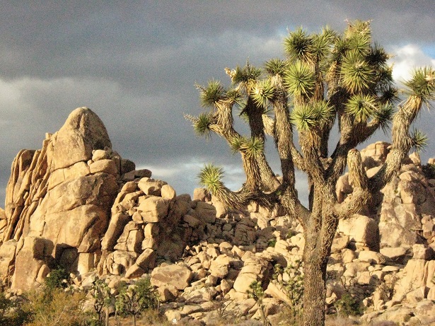
Is it a tree, a flower, or what? Updated 29 Jan 2023.

Strange Desert Plant

Joshua Tree

First of all, the Joshua Tree is not a tree, although it does look somewhat like one.  It is a plant in the Yucca family.  It is most common in California and Arizona but is also found in Nevada, Utah, Mexico and the Caribbean. Early Mormon settlers named the plant after a story in the bible about Joshua reaching his arms skyward in prayer.

Joshua TreeBest places to see it

The best place to see big Joshua Trees in large numbers is Joshua Tree National Park (California).  Also, they can be found at Cima Dome in the Mojave Desert (California) and the Joshua Tree Parkway between Wickenburg and Wickieup in Arizona.

Growth

The Joshua Tree is a very fast-growing plant. Consequently, it will increase by about 7.6 cm (3 inches) per year in the first ten years.  Then it slows down to about half that rate and can live for hundreds of years.  Because it is not a tree, it does not have growth rings, making it difficult to determine the age.  The roots can be up to 11 metres (36 feet) in length.  maximum height is approximately 15 metres (49 feet).

The plant blooms from mid-February to late April.

Joshua Tree

The Yucca Moth

The family of Yucca plants depend on the Yucca Moth for pollination.  The Yucca Moth larvae feed on the seeds.  This is a symbiotic relationship where plants and insects depend on each other for survival.

The town of Joshua Tree

There is a town called Joshua Tree, located in San Bernardino County, California.  The population is about 7,500.

PETRIFIED FOREST TRIP

Explore the Ancient Trees in the Petrified Forest

Petrified Forest

The Petrified Forest is not much of a forest.  There are no trees.   The area consists of semi-desert steppe and badlands. So why is it called a forest?

What happened to the Trees?

Petrifed Forest

There was a humid sub-tropical forest here about 225 million years ago in the Triassic Period.  All was fine in the forest until approximately 60 million years ago, when tectonic activity pushed the area upward, exposing it to erosion from the forces of wind and water.   The trees and other plants were gradually destroyed, and eventually, nothing was left except dirt, sand and rock.

Fossils

Petrified Forest

Typically, most organic matter, such as trees, other plants, and animals, quickly rot away once they are dead and eventually, no trace of them remains.  However, if a tree or animal is covered rapidly by mud and deprived of oxygen before it deteriorates, and then the area becomes dry, the plant or animal may, over long periods of time, become a fossil.   This happens to less than 0.1 per cent of organic material.   A Fossil appears more like a rock than organic matter.   Fossils are, in fact, petrified forms of what was once a prehistoric plant or animal.

Permineralization

In buried plants or animals, if the conditions are right, minerals from groundwater replace the empty spaces in the object once occupied by liquids or soft material.  Once there are no more liquid or soft areas, the matter becomes a solid object and hardens over millions of years into a fossil.  This process is called permineralization.

Exposure

Petrified Forest
Petrified Forest

After being buried for millions of years, sometimes erosion will take away soft soil and, once again, expose the fossil to the surface.  However, most fossils will never be found.

Petrified Forest National Park

OK, enough about geology.  For the average tourist, it is sufficient to view and wonder over the petrified remains of this ancient forest.  This National Park, located in what is now Arizona, was once a vast forest.  Today, you can drive around the park and see the petrified remains of some of the trees.

The park visitor’s centre has an orientation movie, fossil exhibits, books, etc.

Rock Crystal

Typically found within a rock, Calcite Crystal sometimes forms inside petrified objects.   When this happens, wood can take on a beautiful hue.

Petroglyphs

In addition to petrified trees, there are petroglyphs on some of the rocks made by humans who lived in the area between 650 and 2,000 years ago.   Like the hieroglyphics and cave art of Europe and Australia, the petroglyphs are impressive artwork.

Theft

Petrified Forest

Today, the petrified remains of this forest are disappearing due to theft. About 12 tons of petrified wood is stolen from the park annually.


It is illegal to remove fossils from the park; however, you can purchase some souvenir fossils outside the park.  Pieces of petrified wood, when polished, can be quite pretty, with or without calcite crystals.

Badlands


Petrified Forest National Park is not all desert.  A large part of the park consists of terrain commonly known as Badlands.   Badlands are areas made up of rugged, hilly, dry areas.   They are created by the softer soil being taken away by wind and water erosion, leaving canyons, gullies, and strange rock formations behind.  There are many Badlands in the United States and extensive Badlands in Canada,  Argentina and Spain.

Visit

Petrified Forest National Park is intriguing and well worth a visit, even if you are not interested in the permineralization process.  It makes a great day trip for snowbirds spending their winters in Arizona.

The park has no accommodation or campground, but these are available in nearby communities.  Overnight parking is not allowed.