Crossing the Nullarbor Plain in Australia
Updated Apr 2022
The Nullarbor Plain is a flat, arid and mostly treeless area on the south coast of central Australia. It occupies about 200,000 square kilometres (77,000 sq miles) of wilderness that people in southern Australia need to cross to get from the east side to the west or vice-versa (most people go by air). Crossing the Nullarbor is a unique experience that most foreign tourists do not have the time or vehicle to complete. The majority of traffic consists of camping vehicles, large trucks (called Road Trains), and motorcycles. There are few cars.
Preparation
Crossing the Nullarbor was once extremely complicated, but today the highway is paved and is not difficult. Still, you need to prepare for the trip. First, you need to travel to Port Augusta in South Australia. This is the last major town before crossing the Nullarbor. Make sure your vehicle is in good mechanical condition. (I replaced all the belts on my engine and had a mechanic check everything). Next, stock up on enough food and water to last five days. (The amount of time to cross the Nullarbor depends on how many hours per day that you drive and how many stops you make to see things.) The best buy for water is in ten-litre boxes available at all grocery stores. Fill the water tank in your camper if camping. No water is available in the campgrounds on the Nullarbor. You can purchase water at the Road Houses but at a much higher price than in Port Augusta, which is only fair as it has to be transported here. (see below).
The places in this article are listed in order when travelling east to west. Everything will be in reverse order if you are travelling east. In that case, start at the bottom and read up. You will start at the town of Norseman at the west end of the Nullarbor.
Port Augusta to Ceduna
When you are ready, travel to Ceduna on the other side of the Eyre Peninsula. You can either go straight across or around the coast of the peninsula via Port Lincoln. The second route is nicer, but it takes much more time and fuel. I went straight across.
Ceduna is your last town to stock up on anything you forgot at Port Augusta. It is just a little town and has less selection than Port Augusta, but it does have a grocery store.
Fuel up and zero your odometer reading
70 km – Penong
At the 70 kilometre mark, you will come to the village of Penong. Nothing much here, and not worth stopping.
Depending on where you zeroed your odometer, the kilometre reading might be one or two km different from mine.
153 km – Nundroo Road House
There are no towns or villages on the Nullarbor after you pass Penong. There are what the Australians call a Road House, which is just a large building with rooms for rent, a restaurant, a campground and a fuel station. Most people stop at every roadhouse for a break to stretch their legs and use the toilet. Always check the distance to the next Road House to decide if you need fuel.
200 km – Dog Fence
At about the 200 km mark, you will come to a cattle grid in the road (what they call in the USA a Texas Gate). Like a bunch of railway tracks across the road. These grids prevent animals from crossing. Stop here for a minute if you can do so safely. You will see a fence going off on either side of the grid. This fence stretches from the east coast, north of Brisbane, to the south coast just south of this point, a distance of 5,614 kilometres (3,488 miles), making it the longest fence in the world. The Dog Fence is designed to keep Dingos out of the southeast corner of the country where most people live, and many sheep ranches are located. There are no signs to mark the fence.
Yalata
You will pass through the Yalata Aboriginal Reserve. There is no camping, no facilities and you are not permitted to go off the highway. If you wish to travel on aboriginal land, you need a permit. Inquire at the Visitor’s Centre in Ceduna or Norseman before entering the Nullarbor.
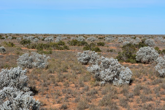
283 km – Nullabor
You have reached the treeless Nullarbor. The word Nullarbor means “no trees”.
300 km – Nullarbor Road House
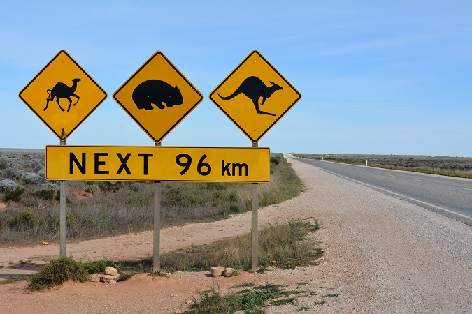
This is an excellent place to stop for your first night on the Nullarbor. The fuel gets progressively more expensive as you proceed to the west up to about 45 cents more than in towns to the east (at the time of writing this). Your ten-litre box of water that you bought in Port Augusta for $4 sells for $15 here. A hamburger and fries will set you back $27. This is to be expected as the staff has to drive to Ceduna to get supplies.
This is the place to photograph the famous sign with warnings of camels, wombats, and kangaroos crossing the road (shown at the top of this post). The one on the west side of the roadhouse is the best one, with the treeless plain in the background. (The first one you will see is at Yalata but don’t bother stopping there).
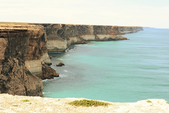
380 km – Scenic Lookout #1
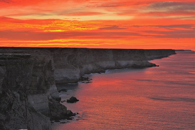
This is the first of three scenic lookouts over the cliffs along the south coast of Australia. We camped here overnight to get some sunrise photos.
Camping
Besides staying at the roadhouses (either hotel or camping), you may camp out in many places for free across the Nullarbor. Many parking areas are marked with a large blue and white letter P where you can spend the night. (Don’t wake up the truck drivers, or they will be very unhappy). There are also many unmarked places where you can get off the road. (Not in the picnic rest areas). If you decide to use the free camping across the Nullarbor, you can get a shower at the roadhouses for about $4. We camped out on the cliffs to get this photo at sunrise. (note that the two photos above are taken from the exact location).
417 km – Scenic Lookout #2
480 km – Scenic Lookout #3
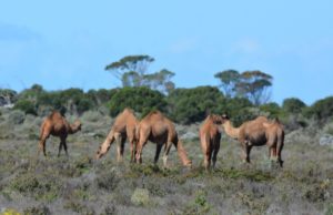 Camels
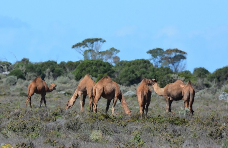
Keep your eye out for camels. We saw some of them on our trip. Watch for Wedge-tailed Eagles and other wildlife. I would not drive at night, although some people do. There is a good chance of hitting some animal on the road. Many of Australia’s animals are nocturnal. The other animal on the sign is a Wombat, which looks something like a hairy pig from a distance. It is a marsupial, about one metre long, with short legs. They are primarily nocturnal.
496 km – The Western Australia Border
Be advised that you cannot take any fruit, vegetables, honey, or seeds from South Australia into Western Australia. Your vehicle will be inspected at the border. Just before the border crossing, there is a fuel station if you need fuel. There is a time change at the border. Set your watch back 45 minutes.
508 km – Eucla
The ruins of an old telegraph station are here.
577 km – Mundrabilla Road House
Another Road House where you can spend the night.
700 km – Madura Road House
790 km – Cocklebiddy Road House
860 km – Caiguna Road House
Another 45 minute time change.
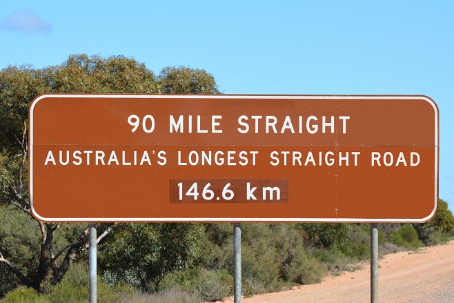
90 Mile Straight
Warning! There is a curve in the road 146.6 km (90 miles) ahead. Australia’s longest stretch of straight road starts after Caiguna.
1,046 km – Balladonia Road House
The last of the Nullarbor Road Houses (or the first one if you are travelling east).
1,136 km – Fraser Range Sheep Station
No fuel or service here, but they do have camping available.
1,240 km – Norseman
You made it! The town of Norseman has stores, camping and other things typical of a small town. This is your last stop to get supplies before heading across the Nullarbor if you are driving east.
Certificate
You can get a certificate to prove your Nullarbor crossing, which makes a good souvenir. If they don’t have any at the Visitor’s Centre, you can get them at the BP fuel station. You can also pick them up at Ceduna Visitor’s Centre and some of the Road Houses if they don’t have any in Norseman. ($2 at most places).