From Ensenada to Guerrero Negro
Driving Baja California – Part Three
Updated July 2022
This is part three of the “Driving the Baja Peninsula” series. Click on the Travel Menu at the top for the other parts.
Colonia Vicentre Guerrero
After three days in Ensenada, we travelled south to a small town called Colonia Vicente Guerrero. It is named after a man who was Mexico’s second president in 1829. We soon left the traffic and crowds behind us. The area is crowded from the American border to Ensenada; further south, there are only small villages. Most tourists don’t venture much beyond Ensenada. After driving for a while, the terrain changed to one of rolling green hills. The road is windy and very narrow, with no place to pull off. It was a little scary at first, but one soon gets used to it. Cars often passed us on curves and on a double line where it was unsafe. I drove slowly and had no problems. The speed limit most of the way was only 60 kph (37.3 mph), so travel is time-consuming.
We passed many agricultural areas where farmers grow tomatoes, strawberries and grapes. I saw one farm growing prickly pear cactus which many people in Mexico eat. I also saw a couple of cattle ranches.
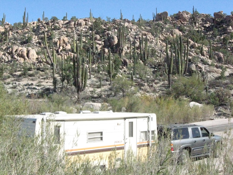
The campground is not in the town but is about one km away. It is very tranquil after the noise of the city. The day was sunny and about 22 (71.6F) degrees. It is a big campground but not many people here. There was one trailer from Ontario there at the time. I can see the ocean a couple of km away, but the dirt road to the beach is in terrible condition. We spent two nights here. Not much to do here, but it was nice to enjoy a couple of days of relaxation in the sunshine.
Military Roadblocks
We got stopped by an army roadblock, and a soldier searched my trailer for drugs. I wouldn’t say I like the idea of a soldier searching my personal property, but Mexico has a big drug problem, and it is good that they are fighting it. This can be intimidating for some people. Don’t let it worry you. The soldiers are just doing their job and will not cause any problems if they don’t find drugs or weapons in your vehicle.
El Rosario
After two nights at Colonia Vicente Guerrero, we drove south to El Rosario. It was only 80 km (50 miles) but time-consuming. The hills got bigger, the roads got narrower, and the speed limit was only 60 kph (37.3 mph) most of the way.
The weather was lovely, with a temperature of about 23 (73.4F) degrees. Unfortunately, it gets cold at night, down to about 6 C (42.8F). This was in the first half of January.
The Baja Gas Gap
After one night in El Rosario, we woke up to the sound of roosters crowing. On this day, we had to drive across what the Mexicans call the Baja Central Desert. Tourists call it the “Baja gas gap”. It is a 350 km (217.5 miles) drive across the desert with no gas stations, towns or services. Spend the previous night in El Rosario so you can get a morning start and have the whole day to cross the desert.


It is not a separate desert but is part of the Sonoran Desert. The Sonora covers almost half of Arizona and the southeast corner of California. From there, it sweeps south into Mexico and then west to the coast in the central Baja Peninsula. The coastal area of California and the northern and southern tips of the peninsula are not part of the Sonora. (for more information about the Sonora Desert, see my article on Deserts of North America here: https://mythatchedhut.com/north-american-deserts/
The Cirio Tree
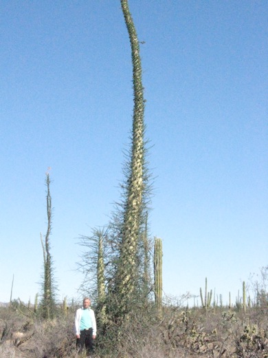
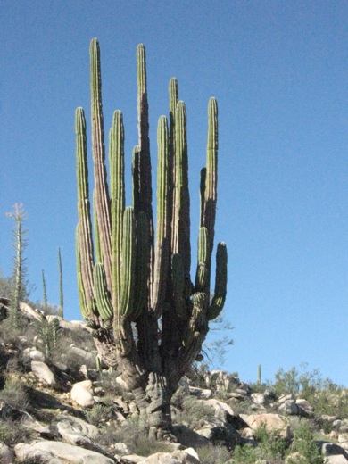
I saw a plant today that grows only in this area. It is called the Cirio tree. (The Americans call it the Boojum tree). It does not look like a tree at all. With white bark and very tiny branches, it looks like a hairy telephone pole. It can grow to a height of 20 metres (65.6 feet). Saguaro cactus grow here, as they do in Arizona because it is part of the Sonora, but in Baja California, they grow bigger. Also, here you can see the largest cacti in the world.
With the narrow, windy roads, driving the 350 km (217.5 miles) across the desert took all day. In addition, the temperature was 31 degrees C (87.8 F).
We went through another army checkpoint just before reaching Guerrero Negro. Then, we crossed the border into the state of Baja California Sur (Baja South). We had to pay 20 pesos to get the vehicle’s underside fumigated to cross the state border. Mexico is divided into states like the U.S.A., and the Baja Peninsula is divided into two states: Baja California and Baja California Sur (south).
Narrow Roads


There were four campers in the campground here, all from Canada. One of them told me about someone who hit an oncoming vehicle on the narrow roads and scraped all down the side of their trailer. The highway is 5.8 metres (19 feet) across. That includes a couple of inches of the shoulder on each side and the yellow line down the middle. When a big truck comes in the opposite direction, there are only a few inches to spare between vehicles. There is no room for error. Going off the pavement is not an option either. Sometimes there is a large drop off the pavement that could cause the vehicle to tip. Good thing I am a good driver. I did okay with it, but it was sometimes a little scary. The road is well paved, just very narrow. When the road needs to be re-paved, they do so without consideration for the shoulders; thus, each pavement layer makes the road higher and higher with a more significant drop-off on the edges. However, most people make it without accident. If you are a good driver, you should be alright.
Guerrero Negro, Baja Sonora
Guerrero Negro is the Spanish version of “Black Warrior”, which was the name of a ship that grounded and sank near here in the 1850s.
The following part of the story will be about four great days in Guerrero Negro.
Spanish Language Tip
Most English-speaking people simply refer to the Baja California peninsula as “Baja”. This is ok in English, but if you are talking to Mexicans, be aware that this is meaningless in Spanish. The word baja means lower or under. Thus, Baja California means Lower California. If you were going to South Dakota, you would not tell people that you are going to “south”. However, as the word has no other meaning in English, we can call the peninsula Baja. Just remember to use the full name when talking to the local people.
Driving Baja California Part Four
Click here for Driving Baja California Part Four
…Interesting-